
Airspace structure of Kyrgyzstan is a network of airways passing mainly in the Western and Central parts of the country. The domestic air routes are mainly passing in the Eastern region of the country that are not used for international flights.
The existing airways allow flying over Kyrgyzstan mainly in the South-West and North-Eastern directions and may create more short air services between the Middle East and Eastern Asia. Radar control of aircraft flying on these airways is carried out in full.
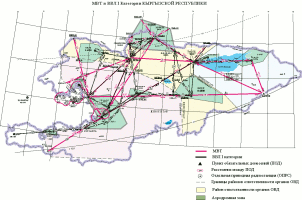
FIR Kyrgyz border with four FIR Neighboring Countries
- With China
- With Uzbekistan
- With Kazakhstan
- With Tajikistan
Kyrgyzstan has 15 air routes with neighboring states:
- With China - 1
- With Kazakhstan - 6
- With Uzbekistan - 5
- With Tajikistan - 3
The Kyrgyz Republic has the common border approximately 650 km. with China.
The new international air corridor is opened on March 20, 2003 between the Governments, located in the South-eastern part of the airspace of Kyrgyzstan. The opening of this air corridor has reduced the distance when flying from Central Asia to South-East Asia and China, which has a significant economic impact both as for aircraft flying through the airspace of Kyrgyzstan by transit and for landing and departing from Manas International Airport.

Operation of air corridor annually attracts the airspace of the Kyrgyz Republic increasing the flow of aircraft. Already flying through the air corridor perform about 45% of all air carriers flying in transit through our airspace.

Kyrgyzstan also has air corridors with Kazakhstan, Tajikistan and Uzbekistan. Their location makes it possible carriers to choose the most convenient routes through the airspace of Kyrgyzstan.
Based on the above, the possibility of bringing to our airspace additional carriers. As a result, significantly increase charges for air navigation services. And the company will have a real opportunity to accumulate financial reserves that are used for the development of the national air navigation.